The terms terroir and climat are often used about the Burgundian vineyards, and referred to when discussing Burgundy wines. While these two terms are related they do have a somewhat different meaning – as climat refer to the place, whereas the terroir could be said to be a place enhanced by human activity, that is giving a product with typicity and specific features and quality.
The last comment does emphasise, that it’s important to underline that the vineyards in Burgundy are indeed man-made, although some of them are very old indeed. Without the continuous work in the vineyards they would never have been established, and furthermore they would not have been maintained and developed for generations.
I must admit I often use both the word terroir and the term climat a bit randomly, and I do try to produce simple maps that show the ownership of the vineyards and location of the individual plots – to possibly link the soil, the geology, the exposure to the sun, the wind and frost – to the taste of the wine. I really want to research this on a deeper level as this is very important in the understanding of the wines.
The description of the geology has however so far often been limited to some words about the sub-soil seen for the vineyard as a whole, yet in recent years the understanding of the geological complexity has increased somewhat.
Map by Françoise Vannier
In reality, we today know that the sub-soil and geology often shift within the vineyards, and basic knowledge as more shallow soil higher on the slope is too generic and too crude to be used for explaining why one wine is lighter than a wine produced from a different plot within the same vineyard.
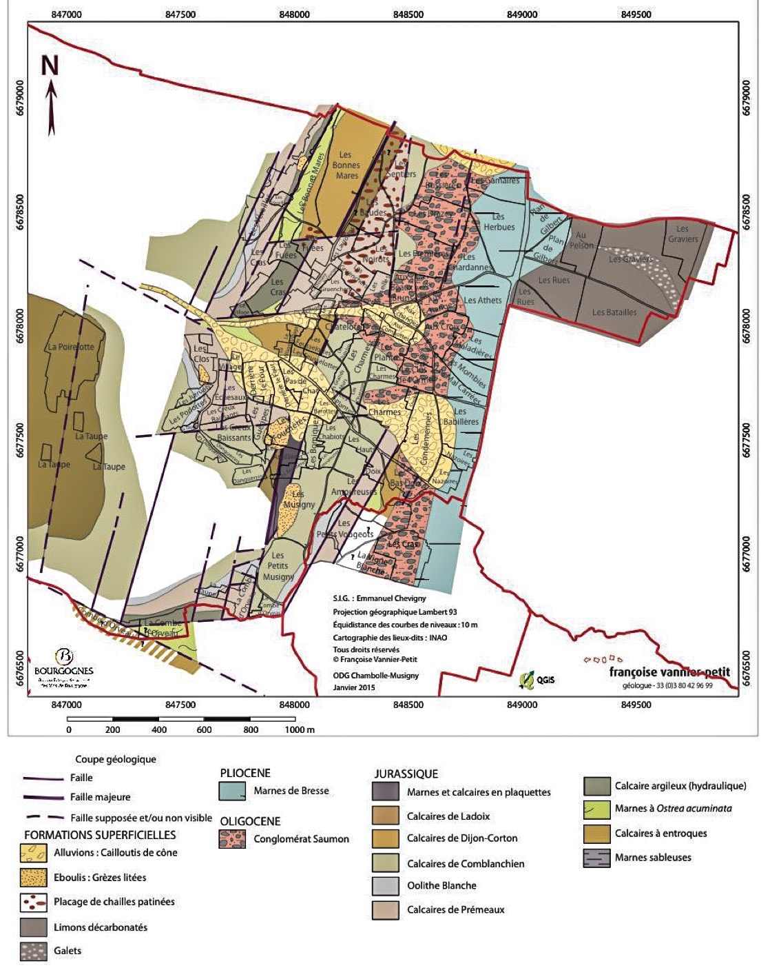
A few appellations – actually more than a few: Marsannay, Gevrey-Chambertin, Chambolle-Musigny, Pommard, Fixin and Les Maranges have actually made quite detailed geological maps, that in rather great detail show the geological structures within the vineyards of the appellations.
These maps are far more detailed than the descriptions found in the old wine books, and yet they are not quite detailed enough to explore the geology and the soil for each individual plot on the vineyard. It should be noted that there are many small plots in the Burgundian vineyards.
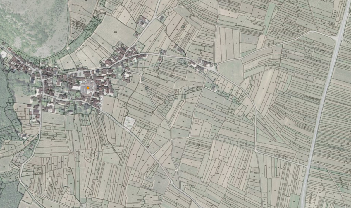
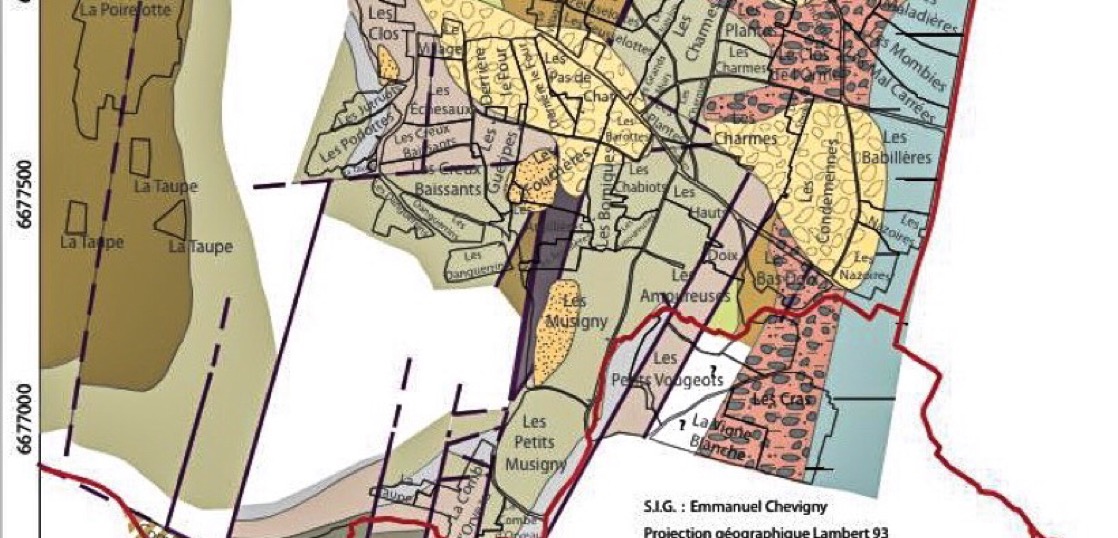
The map below show the vineyard plots around the village of Chambolle-Musigny – just to illustrate how fragmented the vineyards are in some areas.
The new geological maps are all made by Françoise Vannier, who is a very enthusiastic and helpful local geologist who aside from the knowledge also has a true passion for wine.
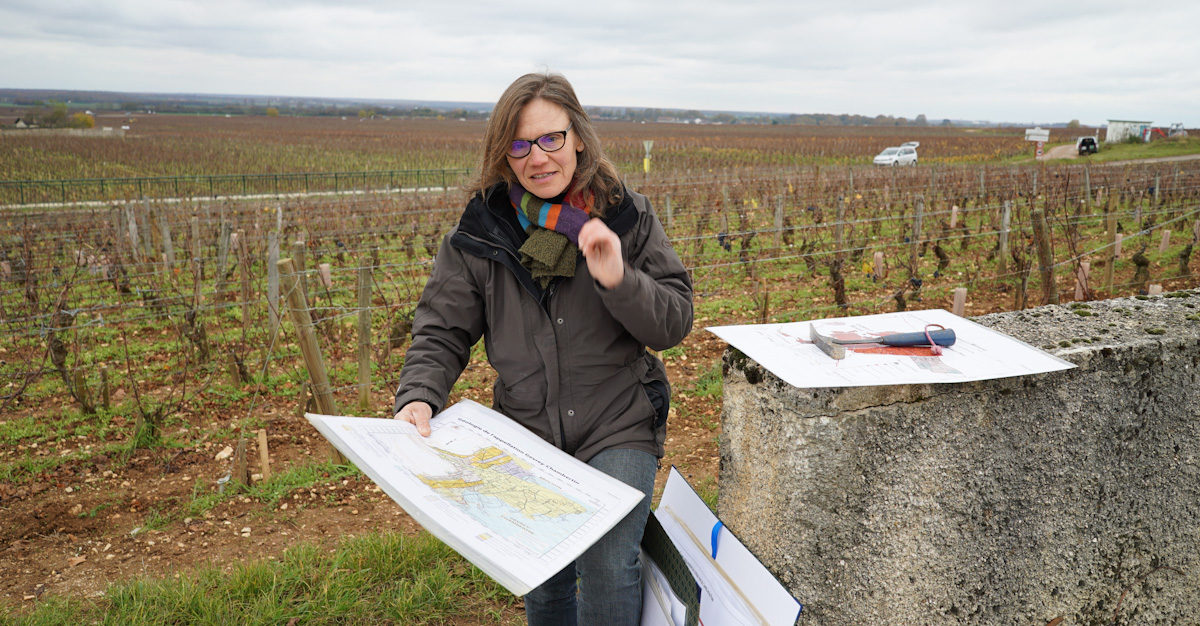
Françoise Vannier in the lower northern end of Bonnes Mares
It is important to note that Geology is about the sub-soil, and the research of the top-soil is also done in some areas – this field of research is however called pedology …
Meeting the Geology Guru …
I wanted to know more about the new geological maps, so I contacted Françoise Vannier – who generously offered to explain the basic geology of Burgundy .. and tell me how she has produced the new geological maps for the appellations mentioned above.
Finally, she would tell me how the maps could and should be used – the level of detail and accuracy. So, we arranged to meet in Vosne-Romanée and then explore one or two vineyards during the next couple of hours on this very cold November day.
We began the journey in the northern core of Bonnes Mares, just near the plots of Bruno Clair, Domaine Georges Roumier and Domaine Robert Groffier
Starting out with a short explanation of the basic geology of Burgundy … finding a level where the Winehog could understand something …
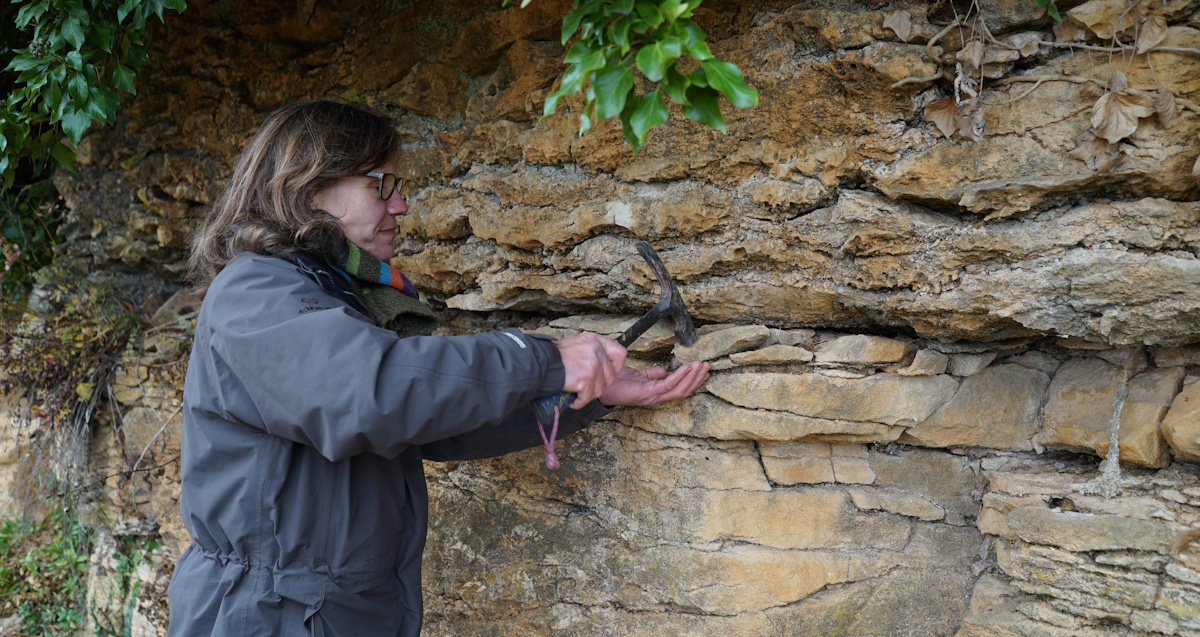
Once sea and seabed
The geology of Burgundy dates more than 300 million years back, and over the millions of years layers have been added or shaped to be like the soil and terroir we know today.
The climate in what we know as Burgundy today was tropical 200 million years ago, and 150 million years ago the area was covered by a shallow tropical sea.
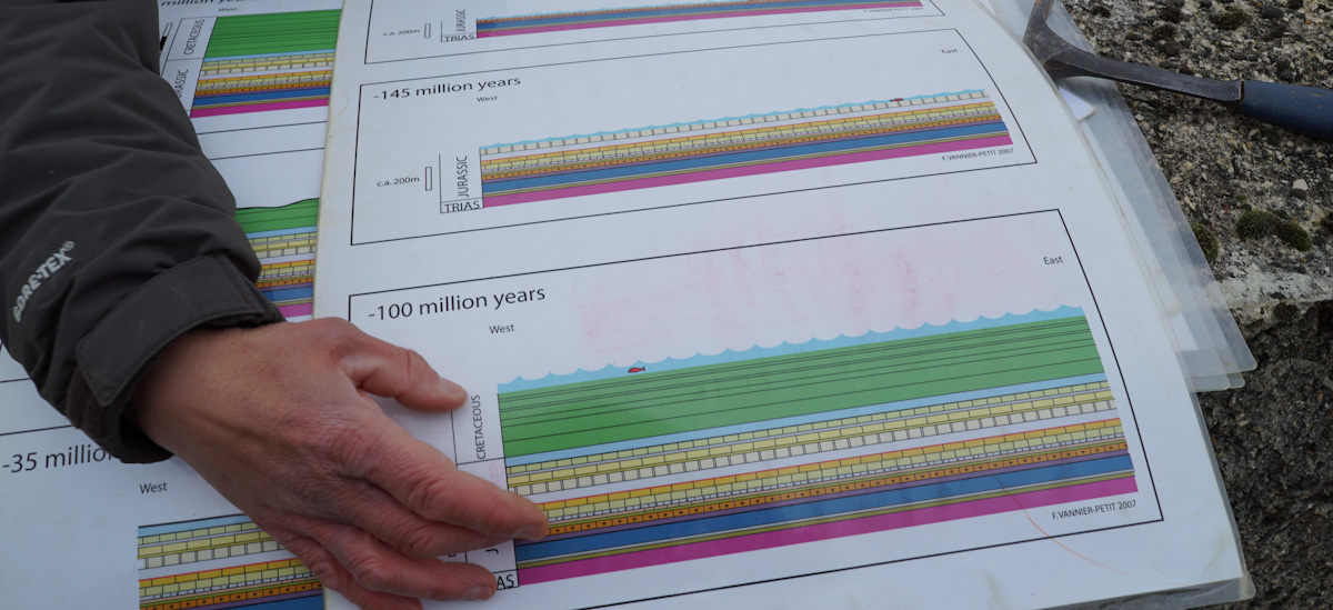
Illustrations by Françoise Vannier
The different limestone soils and geological formations were actually created at the time when Burgundy was covered by this tropical sea. Sediments, fossilised seashells were accumulated at the bottom of the sea and over millions of years compressed to the limestone layers we know from Burgundy.
This is why seashells are quite commonly found in the limestone layers and formations of Burgundy.

Croquille Saint Jacques found in Bonnes Mares
Tectonic complexity ..
The movement of the tectonic plates (the surface of the earth consist of gigantic plates) gave breaks and fault in the geological layers, and during these movements the Alps and the Côte in Burgundy were created.
Along the Côte we find evidence of the different layers of sub-soil, that are revealed as breaks and faults were created when the tectonic plates moved when the Côte was created 60 million years ago.
In some places, deeper layers resurface hence then becoming a part of the soil found in the vineyards thus influencing the minerality and taste of the wines.
By walking in the vineyards, one see the large shifts in the soil within few meters, illustrating the importance of the location of the plots even within the same vineyard.
The classical example is Bonnes Mares where there are both red and white soil – there is a fault in the top of the vineyard.
The more precise explanation is … “the fault is above the white soil, at the western limit of the lieu-dit (Bonnes Mares). The colour changing is associated to a marl layer overlying a limestone layer, just because the environmental deposits changed from a stormy wavy environment (Crinoidal Limestone) to a wave protected muddy bay (Ostrea acuminata Marl)”.
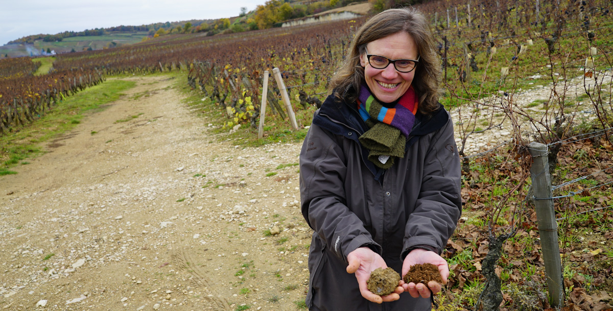
White and red soil in Bonnes Mares
Making the maps
It’s a quite cumbersome job to make the geological maps, as the soil is examined in points covering the vineyard. The distance between the points – hence the number of observation points is determining the accuracy of the maps, although visible geological faults are used as fix points giving some possibilities to extrapolate.
The illustration below shows several geological faults in the area around Bonnes Mares. As it can be seen, the faults can mix the layers – hence changing the geological profile of the area significantly – thus explaining why two neighbouring vineyards can have completely different soils.
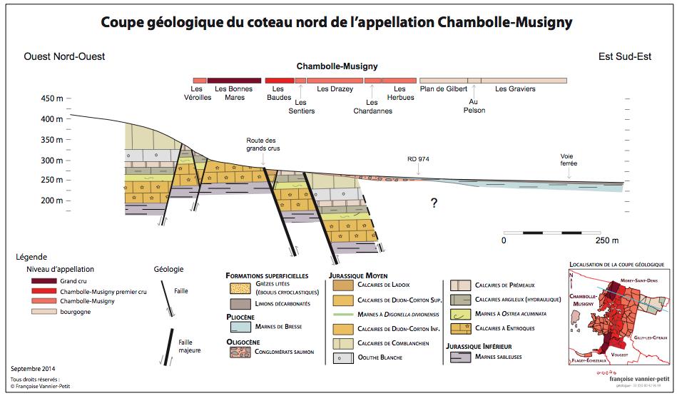
Illustration by Françoise Vannier
The same can also happen within the same vineyard – an example of this is the fault in the middle of Les Amoureuses, that separates the bottom part from the top – see map below.
In this case we know that Domaine Robert Groffier is one of the owners at the bottom part of Chambolle-Musigny les Amoureuses. Groffier have plots located in both in the limestone top part and the Ostrea Acuminata part of Les Amoureuses – giving different expressions of the wines.
Map by Françoise Vannier
In some cases, the shift in the subsoil can be precisely defined and located, if there is a visible fault in the vineyard, in other cases the shift in soil can be more gradual on the surface, as erosion moves the top soil downhill.
The maps and using these
In my view, the new maps does pose a large improvement and a large shift in the previous level of knowledge and the understanding of the terroirs and soils.
In some cases, it also challenges the existing knowledge and we need to look at some of the statements and conclusions made. The world is far more complex .. both a opportunity and a challenge.
I do hope that the rest of the appellations will decide to have new geological maps made – and seen from my perspective the ambition should be detailed maps that allow for a plot by plot interpretation.
Please note – this will never give 100% exact answers, but it will give a greater understanding of the terroirs, and a greater knowledge that can be used when discussing the wines – and this is interesting for both collectors and producers of wine.
I know several producers who plan to do geological maps for their plots, while waiting for a solution at a appellation level.
I do feel that the interest and participation of the growers is crucial, and therefore think a continuation of the work done by Françoise Vannier is very important.
The goal and aim of uncovering the precise geology
In my view, the goal and aim of uncovering the precise geology of the single plots should be a improved understanding of the wine – and especially the influence of the terroir or minerality if you like.
Only with this understanding one will be able to understand more about the wines are shaped by the vinification …
Today it’s often guesswork, and presumably this would be a large element even moving forward – but in the end another level of understanding would be great – and a great support for the work with the UNESCO status of the vineyards.
Wine may have been grown of the soils of Burgundy for more than 1000 years – yet we know very little it seems.
The more one study about Burgundy – the more we know that we do not fully comprehend and appreciate the complexity of this region. Burgundy is for those who want to learn – not for those who think they know it all.
 - A true vin d’émotion – a Burgundy of passion
 - A truly hedonistic wine – lively and enjoyable
 - A vivacious wine for pure indulgance
 - A potential vin d´émotion - frais et léger