On my way though the grand crus of Morey-Saint-Denis I have reached the perhaps most prominent and daunting task – Clos de Tart.
Prominent because it’s a rather legendary monopole that Lavalle rated Tête de Cuvée as the only vineyard in Morey_Saint-Denis – daunting due to the fact that the master of Burgundy maps – Sylvain Pitiot until recently was the estate manager and winemaker at Clos de Tart.
Regardless of the above … I have to say that I have yet to have a Clos de Tart that really blows my mind … I have had some very fine ones over the years, but nothing that quite rivals the best wines from big grand crus of Chambolle and the top vineyards in Vosne-Romanee.
So whats up – with Clos de Tart.
Clos des Tart – a large monopole
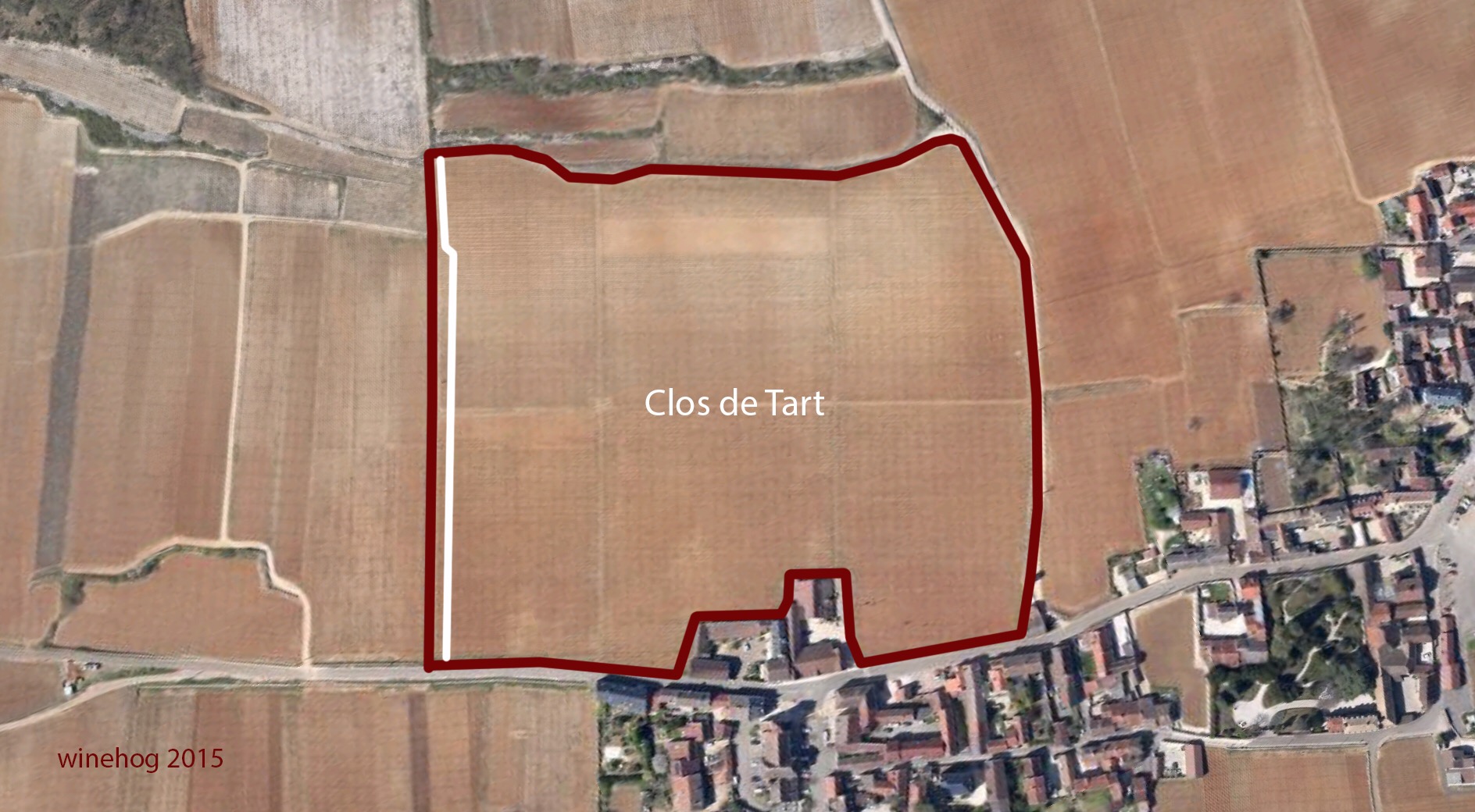
Clos de Tart is a monopole and a Clos – the total area is 7.53 ha and there are two plots included in Clos de Tart today – cadastre no 60 – a 7.2548 ha large plot and a plot that originates from Bonnes Mares – cadastre no 64 – a 0.2780 ha plot in the southern end of Clos de Tart – inside the wall.
The current Clos de Tart can be seen on the map below, where the two plots are indicated by the dotted line.
The second plots indicate that Clos de Tart has been expanded in the past, and that is indeed the case.
So lets go back to the early days of Clos de Tart ….
The expansion in 1966
As mentioned above Clos de Tart have been expanded since the making of the current cadastre in Morey-Saint-Denis in 1957. This expansion took place in 1966 where a small part of Bonnes Mares located inside the Clos and therefore north of the stone wall was included in Clos de Tart. The expansion was approved in a decree of 1. Decembre 1966.
The plot is now an integrated part of Clos de Tart with the vines planted north to south just as the rest of the vineyard. It is however still registered as Bonnes Mares in the cadastre.
This was however not the first expansion of Clos de Tart, as the vineyard was considerably smaller when it was acquired by the Marey family as bien national in 1791. But lets try to go back step by step.
Expansions between 1861 and 1966
In Lavalle 1 and the 1861 classification 2 the area of Clos de Tart is quoted as 6.8750 ha – i.e. 0.6650 ha less than the current area and 0.3770 ha less than before the Bonnes Mares plot #64 was included in 1966.
This means that 0.3770 ha has been included between 1861 and 1966. Looking at the old napoleonic cadastre maps from 1828 it can be seen that there are three rather obvious areas where the expansion took place – see the map below.
The first area is cadastre no 929 (old cadastre from 1828) located just south of the estate buildings of Clos de Tart and Domaine Groeffier. This plot was not included in Clos de Tart in the 1861 classification, and looking at the map it’s a plot of around 0.25 ha.
The two other expansions are perhaps less obvious, but looking at the border between Clos de Tart and the village terroir above – La Rue de Vergy – the border seems to have changed somewhat in both the southern and northern end … including at least some parts of plots in La Rue de Vergy. The old cadastre maps are not very accurate, but to me it’s pretty clear that a quite substantial area was included at some point between 1861 and 1953 when the new cadastre was established in Morey-Saint-Denis.
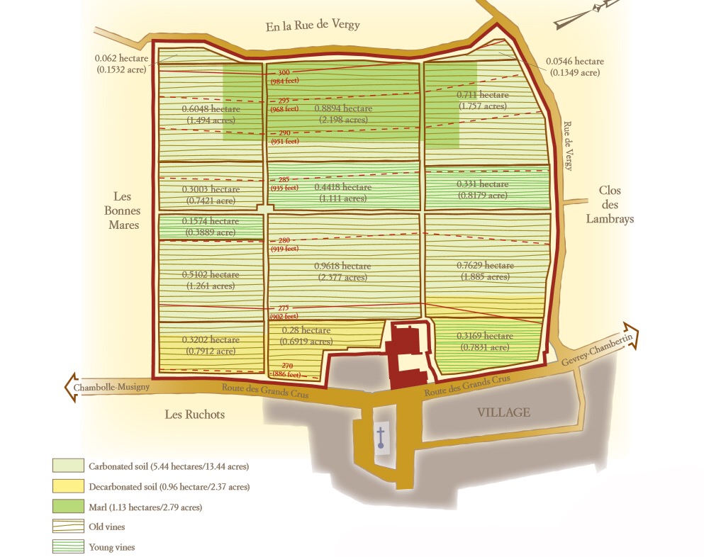
The map below made by Domaine Clos de Tart shows the current sub-climats of Clos de Tart, and looking at the two small plots in the top of the vineyard, these are a quite good approximation of the area included from La Rue de Vergy. The map show that the “plots” are 620 and 546 square meters – in total 0.1166 ha.
So adding it all up … the area in 1861 was 6.8750 ha, and 0.1166 ha was added in the top of the vineyard and around 0.25 ha was added in the bottom of the vineyard south of the Groffier estate buildings and finally 0.2780 ha of Bonnes Mares that was added at the expansion in 1965. The four areas mentioned – in total 0.6446 ha – is very close to the actual expansion (0.655 ha) from the size quoted in 1861 to the current size.
While this is an approximation, the expansion after 1861 seems to be quite well documented by the research done above … but when was this expansion done?
Looking at Rodier4 1920 – he mentions that Clos de Tart is 7 ha. This indicates that 0.1250 ha was included in Clos de Tart between 1861 and 1920. Looking at the expansions mentioned above it seems likely that the two plots on the border to La Rue de Vergy are the ones that were included first – i.e. before 1920, while the plot south of the Groffier estate was included after 1920.
I have no sources that in any way documents the inclusion of this plot, but it is likely that this happened in 1939 when the AOC Clos de Tart was established in a decree from January 4th 1939. I have however so far not been able to find a copy of this decree.
The expansions between 1791 and 1855
When Nicolas-Joseph Marey acquired Clos de Tart as bien national in 1791 the total area was 6.17 ha according to Clive Coates5. If this is true 0.705 ha was added to Clos de Tart … presumably between 1791 and 1828 when the first cadastre for Morey-Saint-Denis was completed.
You need to login to read the rest of this article. If you are not a subscriber, use the subscribe function and sign-up.


 - A true vin d’émotion – a Burgundy of passion
 - A truly hedonistic wine – lively and enjoyable
 - A vivacious wine for pure indulgance
 - A potential vin d´émotion - frais et léger